Volume 23
Number 2
Winter 2006
Number 2
Winter 2006
|
Volume 23
Number 2 Winter 2006 |
|
Departments:
Campus Views | Letters
| News & Notes | Parents
| Class
Notes | Aggies Remember
| End Notes
|
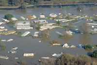
Headed for a Bad BreakGeologist Jeff Mount predicts a 64 percent chance of a massive levee failure in California’s Delta in the next 50 years, but governmental action and money are slow in coming. By Teri Bachman
And that speaks volumes about the challenges ahead.
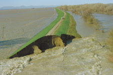
Much relies on this 2,600-mile system of earthen embankments—a chain that’s only as good as its weakest link. And some of those links are weak, indeed. It’s a worrisome picture, and no one has been more vocal in pointing that out than UC Davis geology professor Jeff Mount, a watershed expert and, until recently, a member of the state’s Board of Reclamation, which oversees flood control for the Central Valley. He has calculated the odds of catastrophe: a very scary 64 percent chance of massive levee failure in the Delta within the next 50 years. And his concerns for the state’s levees go beyond the Delta region. He points out that increasing urbanization throughout the Central Valley is overtaxing a poorly maintained flood control system. It’s a message that has not been popular with developers who would like to build behind those levees, nor, apparently, with the governor’s office. Mount, the Reclamation Board’s only scientist, was fired by Gov. Schwarzenegger in October along with the rest of the board. Crisis, part I: In the Delta
|
|
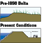
Add to that something called “subsidence”: the gradual sinking of the land behind the levees from oxidation of the peat soil and compaction by farming. Many Delta islands are now 25 feet below sea level.
If a major levee failure were to occur in the Delta, it would have devastating consequences for the entire state. The Delta is the hub of the state’s water system. Water flows from the Sierra via the Sacramento and San Joaquin rivers and their tributaries, through a network of fragile channels and into pumps in the South Delta that put it into canals heading to the Silicon Valley, the Central Coast and Southern California. A major levee breach would draw brackish ocean water into the Delta—the “Big Gulp,” Mount calls it—contaminating irrigation and drinking water supplies and perhaps stopping the southward flow for a year or longer.
Levee failure would also impact other infrastructure, including rail lines, gas pipelines and highways. Pacific Gas & Electric Co. is concerned enough that it is now planning to build a new pipeline in the Delta 100 feet below ground, where it would be out of harm’s way in case of what the company sees as a real threat of a collapsed levee system.
A study by Mount has shown that the risk is indeed real. He conducted an analysis with UC Berkeley colleague Robert Twiss that found through some simple model simulations that the odds are two in three of “major destruction and rearrangement of this system of levees” from a devastating event: an earthquake or large flood.
It’s that prediction that has got Mount’s name in post-Katrina news stories across the country that speculate whether the Golden State might be next.
While some critics find Mount alarmist, alumnus and Reclamation Board General Manager Pete Rabbon ’75, M.S. ’76, notes, “There isn’t anybody out there from a scientific perspective contradicting him. He’s highly regarded in the scientific community and in the flood management community. I think he is just trying to advocate good public policy for flood protection.”
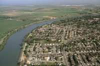
While levees in the Delta protect much of the state’s drinking water, levees throughout the Central Valley protect the homes and people who live behind them. Central Valley levees suffer many of the same problems faced by the Delta structures.
“The Central Valley levee network is old, aging and being asked to do something it cannot: protect urbanization,” says Mount.
|
Levees in the Central Valley have failed some three dozen times in the past 25 years. In 1986, the Yuba River flooded the communities of Linda and Olivehurst near Marysville. The state—recently found legally liable for damages from the collapse of the levee—is just beginning to settle claims totaling more than $500 million with the some 3,000 people affected. In 1997, a Feather River flood, again near Marysville, killed six and forced 120,000 from their homes—the largest evacuation in the history of California.
In the Sacramento area, a U.S. Army Corps of Engineers levee survey completed in 2003 found that 89 miles needed significant repairs. While many of those improvements have since been made, flood protection in Sacramento is still half of what New Orleans had before Katrina, with California levees built to withstand floods predicted to occur once in every 100 years and New Orleans’ levees built to a 250-year standard.
And even that 100-year protection is now being called into question. It’s based on weather models that are outmoded and on older levee certification criteria. New standards recently developed by the Army Corps based on a better understanding of seepage and the cause of levee failure will most certainly mean that many miles of levees will be decertified.
People living behind a decertified levee are considered to be within a flood hazard zone, and they are required to purchase federally subsidized flood insurance. A decertified levee also has the potential to halt development behind it—a reason that local communities resist decertification efforts so strongly, notes Mount.
But he adds, “When agencies allow homes behind levees they are making one assumption. They are deciding that the occasional instances of human suffering are worth the economic benefit of development.”
They are also, he contends, hoping that “the inevitable will not occur. That is what most politicians are gambling on: Not on my watch.”
Concerned about that potential for human suffering, Mount and his fellow Reclamation Board members had recently taken a tougher stance on development in floodplains, deciding to exercise a power that the board had long held but until recently rarely used. They had decided to assert the board’s authority under the California Environmental Quality Act to review and make recommendations on projects in flood zones.
Shortly thereafter, Gov. Schwarzenegger replaced the board—action his office insisted had been in the works for months and was not the result of the board’s more aggressive stand.
What’s needed is a rigorous assessment of levee integrity and a regular program of maintenance. But that, of course, costs money.
After the state’s 1997 flood, the state was energized with new plans and new funds for flood control and levee repair, but when the state’s fiscal crisis hit a few years later—during “dry” years—concerns proved short-lived. By 2003, a crisis was building, and Stein Buer ’71, M.S. ’78, another of the many UC Davis alumni who work in water management in the state, raised the alarm. Buer, then chief of the Department of Water Resource’s flood management division, reported that budget cuts to the department had significantly weakened its ability to repair flood control structures and to respond to emergencies.
Buer has since moved on to become executive director of the Sacramento Area Flood Control Agency (SAFCA), but the Department of Water Resources continues to plead for the funds it needs to do its job. A report in January 2005 estimated that $2 billion is now needed for capital improvements to the Central Valley’s flood control system over the next 10–15 years.
Historically, levees have been built through a cost sharing formula apportioning, roughly, 65 percent to the federal government, 25 percent to the state and 10 percent to local districts. The costs for operation and maintenance are borne by a patchwork of local assessments. In rural areas where farm profits have been squeezed, maintenance can be minimal.
In the Delta, because of its statewide benefit, the state also contributes to upkeep through the Delta Levee Maintenance Program. That program had been scheduled to expire July 1; legislation to extend the program to 2010 passed this fall, but only after it was stripped of all language about funding the program.
Nevertheless, Gov. Schwarzenegger has stated he’s committed to improving the state’s flood infrastructure. His budget includes $9.7 million to restore levee maintenance worker positions cut in previous years, and he is asking that the California congressional delegation seek some $90 million for levee improvements that was authorized last year by Congress but has yet to be appropriated.
Another possibility is a bond measure. One that would have raised $1 billion for levee repairs was tabled in the State Senate this fall but will be raised again next year. Other options include “beneficiary pays” plans with “beneficiary” defined broadly—it could theoretically include everyone from water drinkers in the south to recreational boaters.
|
But both Rabbon and Mount hope that the state takes a broader view in its search for solutions to the levee problem.
“To me the best solutions are the ones that in the long term have minimal costs,” says Rabbon. “I’m an engineer, and I’ll admit that Mother Nature will beat me every time.” He advocates that, when possible, water be allowed to flow where it chooses—in other words, onto the floodplain.
Mount waxes enthusiastic about one such solution right in Davis’ backyard: the Yolo Bypass.
“It’s the single most effective flood control method we have in the Central Valley, period,” he says. “Not only does it do a terrific job of flood management by diverting floods away from Sacramento, but it also turns out to be great at ecosystem restoration.”
There are many floodplains that could be put to similar use, says Mount—along the Sacramento River to the north and major portions of the San Joaquin area. But that can occur only if the land is not used for housing developments, and that, Mount says, requires regional planning.
“Local communities need money. They are really in a bind and want the development,” says Mount. “So I don’t think communities can make good decisions. We need regional land-use planning mechanisms because floods are regional features.”
Dams, too, are an important component of flood management, but their effectiveness can be limited.
“Dams have failed us for lots of reasons—not the least of which is that we ask a lot of them,” says Mount. “They supply water, hydropower, recreation, ecosystem restoration and flood control. Four of those goals want more water in the dam. One of those—flood control—requires less.”
Planned modifications to Folsom Dam—to raise it by seven feet and modify its outlets—will go a long way toward making Sacramento safer, but the cost, miscalculated by the Army Corps of Engineers, is now $500 million more than initially thought.
In the Delta, potential solutions include one that many are reluctant to even mention: a peripheral canal. A pipe or canal could take water from the Sacramento River directly to its destinations, bypassing the Delta and its shaky levee system entirely. A referendum for such a solution was defeated in 1982 because of costs, environmental concerns and the fear that it would make it too easy to send even more water south. But the idea has surfaced again, recently suggested by former interior secretary Bruce Babbitt.
“That issue in the early 1980s was so poisonous it literally created a cultural divide between Northern and Southern California,” notes Mount. “But it is back on the table for discussion as we are beginning to realize that the present system is not reliable or sustainable over the long term—or even the near term.”
But he cautions: “A canal is not a silver-bullet solution to this problem. It does nothing for the rest of the Delta. You still have all the problems there with shipping, power, water supply, ecosystem restoration. But it might be some component of a solution in the future.”
In the meantime, what’s a concerned citizen to do? For those living on floodplains, “buy insurance,” says Mount. The Department of Water Resources notes that during a typical 30-year mortgage period, a homeowner living behind a levee has a 26 percent chance of experiencing a flood larger than a 100-year event. This is almost twice the likelihood of a house fire.
Mount advises anyone who doesn’t want a New Orleans-sized catastrophe to occur in California to let their legislators know they are concerned. “It takes a lot of grassroots efforts to bust out of our traditional role,” he says.
The Department of Water Resources, in its January 2005 report, called California’s flood control system a “ticking time-bomb” and recommended a number of strategies to improve flood protection, including evaluation of all levees using the new Army Corps standards, rehabilitation of levees found to be deficient, creation of a sustainable funding source for maintenance and a requirement for all homes and businesses in flood-prone areas to carry flood insurance.
Assembly Bill 1665, authored by Assemblyman John Laird (D–Santa Cruz), advanced many of those recommendations, though its final version had been stripped of its key provisions after opposition from various corners. Its final iteration required annual assessment of levees and notification of property owners living in levee protection areas. It will likely be considered again after the Legislature reconvenes in January.
SAFCA’s Buer, who has some two and a half decades of experience in flood management, describes himself as hopeful.
“I’m optimistic that when we come back and work together with the state and other agencies in the coming months that we can come up with a package that is supportable and can pass,” says Buer.
And if not? Well the Resource Board’s Rabbon notes that he lives behind a levee in Sacramento’s Greenhaven/Pocket area.
“And this is just a coincidence, but I do have a boat in my garage,” he jokes. “And I always tell my neighbors, if you see me pull my boat out in the winter, that is a subtle hint.”
![]()
Teri Bachman is editor of UC Davis Magazine. Levee and flood images courtesy of the California Department of Water Resources.